Is Our Coastline in Grave
Danger?
By Tony Noerpel
April
20, 2007
The
Intergovernmental Panel on Climate Change recently published its Fourth
Assessment Report Summary for Policy Makers, representing the consensus opinion
of the scientific community on global warming. The report, which has been
endorsed by government and industry, shows that human activities have warmed
the Earth by 1.2 degrees Fahrenheit over the last 40 years and 1.6 degrees over
the last century, whereas natural forcing functions would have slightly cooled
the planet over the last 60 years.
That
much is certain. What�s not certain is how people will respond to the warning.
There
is some controversy over the Fourth Assessment Report�s projections for rise in
sea level--between 7 and 23 inches during the coming century.� This is devastating enough to be sure, but
the upper limit to that range may be even higher than 23 inches. The report�s
projections include thermal expansion and water from non-polar glaciers which
are all expected to melt within several decades.� But the report specifically excludes melt water from Greenland
and Antarctic glaciers. According to climatologist Stephan Rahmstorf, those
water sources are excluded because they are not well understood.� One of the most famous glacier scientists,
Ohio State University professor Lonnie Thompson, said the report�s authors
"don't take into account the gorillas � Greenland and Antarctica.� I think there are unpleasant surprises as we
move into the 21st century."�
The
fact of the matter is recent measurements show that sea surface rise matches
the worst-case projection of the Fourth Assessment Report quite well, and it
exceeds the upper limit projection.� If
this trend continues, sea level will rise 35 inches by the end of the century.
In other words, the actual mean sea level rise might be 1 foot higher than the
worse case level projected by the Fourth Assessment Report.
Only
recently, measurements of Greenland and Antarctic ice sheets have been made
using the gravity recovery and climate experiment satellites, which have been
orbiting the earth 137 miles apart since 2002. A change in gravity due to a
change in thickness of the ice sheet below is detected by small changes in the
distance between the satellites. Scientists can detect changes in distance
equivalent to one fiftieth of the diameter of a human hair.
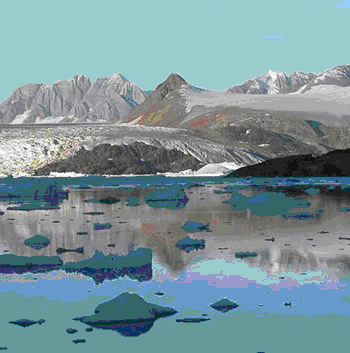
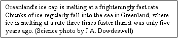
Greenland
contains about 10% of all the fresh water on Earth and if the entire 2.85
million cubic km of ice were to melt, it would lead to a global sea level rise
of 23.6 ft. This would inundate most coastal cities in the world and remove
several small island countries from the face of Earth.� According to the Jet Propulsion Laboratory,
Greenland is losing 48 cubic miles of ice a year.�
 The Antarctic ice sheet contains about 87% of the fresh water on Earth,
and if it melted sea level would rise 63 meters.� According to glacier scientists Isabella Velicogna and John Wahr,
Antarctica is losing ice mass at the rate of between 16 and 51 cubic miles a
year averaging 37 cubic miles per year.�
The Antarctic ice sheet contains about 87% of the fresh water on Earth,
and if it melted sea level would rise 63 meters.� According to glacier scientists Isabella Velicogna and John Wahr,
Antarctica is losing ice mass at the rate of between 16 and 51 cubic miles a
year averaging 37 cubic miles per year.�
In
conclusion, neither the Greenland nor Antarctic ice sheets have been projected
to contribute to sea level rise during the next century according to the Fourth
Assessment Report. However, recent measurements confirm that both ice sheets are
shrinking at an accelerated pace, so the worst case projected by the report is
actually less extreme that what we�re likely to face in the next few decades if
we don�t reduce global warming.